Mount Fuji

Home | Pacific Ring of Fire | Mount Fuji | Fun Facts | Photos | Links

mount-fuji-japan-jpn438.jpg

Figure 4 Photo of The Port of Tagonoura below
Mt. Fuji.
Source:http://www.planetware.com/
picture/japan-mount-fuji-jpn-jpn438.htm

Mount Fuji stands 3,776 metre (12,388 ft) high and is located in Honshu which is the largest island in Japan.  This scared mountain is approximately 100 miles away from the Tokyo which is the capital of Japan. It is said that on a clear day the visibility from the island to Tokyo is impeccable and truly a wonder of the world.  Mt. Fuji is seen by the locals as a scared spot which holds a religious symbol to them.  The mountain is very special in regards to the fact that it is just not one volcano, but rather it has four within its core; Sen-komitake, Komitake, Older Fuji, and Younger Fuji.


Mount Fuji is classified as to be an active volcano with a low risk of eruption even though the last eruption of the volcano was back in 1707.  The mountain has had approximately 63 eruptions in the past 9000 years scientists have said. Komitake which is the oldest of the volcanoes was active back in the middle of Pleistocene era whereas Older Fuji was active between 80,000 and 10,000 years ago.  The growth of Younger Fuji has been a result of volcano eruptions within the past 10,000 years.


This natural wonder is a stratovolcano shape which is “a relatively long-lived volcano built up of both lava flows and pyroclastic material” (Webster’s Dictionary, 2007). Mt. Fuji’s composition is mainly basaltic and 50% silicon, however during the Sen-komitake phrase, it was composed of andesite.

landsat_gallery_374_1_450.jpg

Figure 5 Aerial photo of Mount. Fuji.

Source: http://landsat.usgs.gov/gallery/detail/374/


mt-fuji-torii-near-summit-wp.jpg

Figure 6 Tourist sitting at the Torii gate on the summit of Mt. Fuji.
Source: http://www.sacred-destinations.com/japan/images/fuji/mt-fuji-torii-near-summit-wp.jpg


Mount Fuji is located in a distinctive area due to it being in a place where the Eurasian Plate, the Okhotsk Plate, and the Philippine Plate meet.  There is also subduction that occurs with the Philippine Sea Plate slowly going under Japan; however the subduction is not the only cause of the movement of Mt. Fuji.  Scientists have reported that the Philippine Sea Plate is splitting into two parts where a magma chamber is being created in the gap.  This hot spot is representing the fuel needed for Mt. Fuji to become more active in years to come.

japan_trenchs.jpg

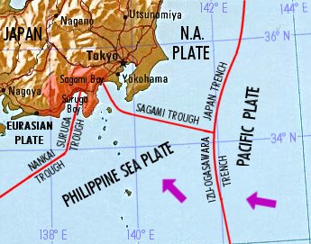
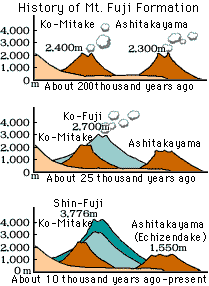
Figure 7 The picture displays the subduction zone of where the Philippine Sea plate is sinking underneath Japan.

Source: http://images.google.com/imgres?imgurl=http://jove.geol.niu.edu/students/mdare/VirtualFieldTrip/

Mt_Fuji/japan_trenchs.jpg&imgrefurl=http://jove.geol.niu.edu/students/mdare

/VirtualFieldTrip/Mt_Fuji/MountFujiGeology.html&h=271&w=345&sz=34&hl

=en&start=1&um=1&tbnid=v0Kqve24bZuU3M:&tbnh=94&tbnw=120

&prev=/images3Fq%3Dmt%2Bfuji%2Btectonic%2Bplates%26svnum%3D10%26um%3D1%26hl%3Den%26rls%3DSUNA,SUNA:2006-04,SUNA:en%26sa%3DN


formation.gif

Figure 8 Chart demonstrates the formation of Mount Fuji

Source: http://images.google.com/imgres?imgurl=http://www.

earlham.edu/~ steelem/eruptfuji.gif&imgrefurl=http


fuji_five_lakes.gif

 Figure 9 Map of Mount Fuji and the surrounding area.

Source: http://www.digi-promotion.com/pics/fuji_five_lakes.gif